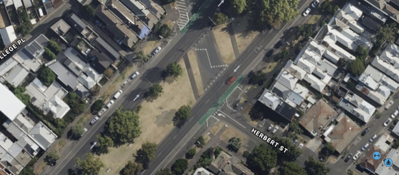
Chinese (Simplified) Chinese (Traditional) English French German Greek Hindi Indonesian Italian Japanese Korean Malay Spanish Vietnamese Print Do we want another Kings Way barrier to divide Port Phillip? 08 Aug 22 By a concerned Mills Street ResidentImage attribution: Google Image of Herbert-Montague Street and Kerferd Road intersectionThere is increasing concern regarding the proposed Shrine-to-Sea Avenue proposed by the Victorian Government in partnership with the City of Port Phillip. Residents are concerned the project may not only divide Port Phillip but also divide the Albert Park locality. The path to Beaconsfield Parade from Kingsway along Albert Street and Kerferd Road is already clearly delineated. SourceMany residents have voiced their concern that a dedicated path with intersecting side roads blocked off will seriously and permanently create a barrier that will have an effect similar to that which occurred when the enforced Kingsway was forged through the middle of South Melbourne – creating a freeway dividing the then city into two distinct areas with little communication between.Residents are concerned that the closure at Herbert-Montague Street and Kerferd Road, Albert Park may be the beginning of a series of Council planned closures to implement this divisive community policy. The Herbert and Montague Streets closure now appears to be permanent following extensive delays of the trial that started in February 2021, with the traffic data collection. The Council website states ‘Due to Covid-19 restrictions, we have been unable to record the final traffic data counts and will conduct these as soon as restrictions ease. Until this time the trial will remain in place’. SourceThere are good reasons for not implementing this and other road closures:1. An inconvenient barrier to the Albert Park shopping centre from the east of Kerferd Road and to Middle Park from the Albert Park side.2. All street closures have negative impact on other surrounding streets by re-directing and increasing traffic in an abnormal pattern. Traffic will be increased on: a. Canterbury Roadb. Hambleton Streetc. Richardson Streetd. Merton Streete. O’Grady Streetf. Little O’Grady Streetg. Finlay Street3. Inhibits community interaction for an ageing population4. It is not any safer for pedestrians or cyclistsThe traffic management solution at Danks Street where it crosses Kerferd Road (see Google image below) has worked well to remove the vehicle danger of the intersection. If prevention of vehicle accidents is the concern, then a similar solution can easily be implemented at the Montague-Herbert Street intersection with Kerferd Road.