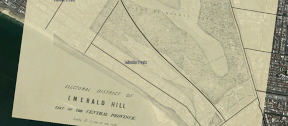
Chinese (Simplified) Chinese (Traditional) English French German Greek Hindi Indonesian Italian Japanese Korean Malay Spanish Vietnamese Print New Tab How Middle Park has changed since 1857 By Matthew FaganMiddle Park residents may be interested to see how our suburb has changed since 1857. I have overlaid maps from 1857 on Google Earth, with a little adjustment for size, orientation and varying the transparency of the old maps. This is a middle level transparency overlay from 1857.Middle Park residents may be interested to see the extent of the lower lake which bordered the park and no longer exists. You can see the lower lake bordering Canterbury Road and Park Street on this plan. The map shows planned development indicating that a good number of the houses were built on what was a lake. You can see also the historical boundary between the City of St. Kilda and the City of South Melbourne which explains the dog leg in Fraser Street. If you look at the 1857 map the diagonal line was in fact at right angles to St. Kilda Road and joined to the old Fraser Street which was at right angles to the shoreline. This created the kink in Fraser Street with the bent section across the now non-existent lake. And Fraser Street is still the boundary of St. Kilda West and Middle Park.And on the North from about Armstrong to Mary Street, the lake continued, explaining much of the deep depression on the North Side of the St. Kilda railway line which was completed only 4 years after the map in 1857 but which is shown, albeit slightly differently, on the map. I have highlighted on the ‘transport’ routes to allow the easy alignment and scaling of the map. In the next map you can see more clearly without these modern lines and with no transparency, the map fits perfectly.In the next map with high transparency, you can see how the islands in the lake were altered.You will note here I have added a Port Melbourne map showing the lagoon which blocked access to Middle Park. Source: https://www.victorianplaces.com.au/middle-park Canterbury Road was built in 1876 before Beaconsfield Parade. Beaconsfield Parade was originally a rapidly built military road to rush cannon from Port Melbourne to Kerferd Road to St. Kilda, to defend against a Russian invasion that never came. Many of the streets of East St. Kilda/Balaclava were named after the Crimean war and fear of a Russian war was high. Alma is a river, the battle of Alma, Sebastopol, Crimea, Inkerman, Balaclava itself the reason for the woollen hats of the time and notorious for the Charge of the Light Brigade up the valley from Balaclava to the Russian positions. I have enjoyed adding the historical maps to Google and put history in the context of today.