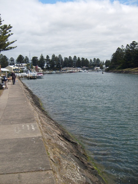
Chinese (Simplified) Chinese (Traditional) English French German Greek Hindi Indonesian Italian Japanese Korean Malay Spanish Vietnamese Print New Tab Moyne River Training Walls Port Fairy The Moyne River Training Walls works were undertaken between 1869 and 1874 to make the Moyne River navigable and allow seaborne trade to develop at Port Fairy, in particular to serve demand for shipping wool. A pier and tramway constructed by 1860 to serve shipping in the Bay was a dismal failure, and a railway link was not achieved until 1890, so Port Fairy was dependent on a navigable Moyne River for its growth. River access for coastal vessels was achieved in 1872, and the first vessels Elizabeth and Rambler were towed through the entrance by the paddle steamer tug Surprise. The Moyne River Training Walls extend from the pedestrian footbridge at Gipps Street on both sides of the river to the moles projecting into Port Fairy Bay and include walls along the South West Passage. Basalt was quarried from sites on Griffiths Island, and the battered basalt walls contain and project the river flow into the bay, making use of coastal wave force from the South West passage to project the suspended river silt through the mouth. The concept was developed by NSW engineer E O Moriarty with later alterations by W H Steel, Inspector-General, Public Works Department, British harbour engineer Sir John Coode, and E M De Burgh, Chief Engineer for Harbours, NSW. However, the self-flushing action created navigational problems, and the South West passage was sealed off from the river in 1911. Since then regular dredging of the Moyne River has been required in order to maintain navigability. While the walls permit access from the sea into the river, the structures have led to a significant alteration of the landscape from coastal erosion and sand accumulation, significantly altering the form of Griffiths Island, a sand dune over a basaltic intrusion that protects the entrance of the Moyne River to the sea. Contributor Author90 90, Author, Attribution Victorian Heritage Register Citation: Copyright © The State of Victoria, Department of Environment, Land, Water & Planning 2017 Attribution: Copyright © The State of Victoria, Department of Environment, Land, Water & Planning 2017 License: CC by 4.0 https://www.data.vic.gov.au/data/dataset/victorian-heritage-register